FIRST ALERT FORECAST: Record breaking 2020 hurricane season continues
BATON ROUGE, La. (WAFB) - To say that the 2020 Atlantic hurricane season has been active is probably an understatement. 2020 has set a number of records in terms of tropical activity.
Now that Tropical Storm Iota has formed in the Central Caribbean, 30 named storms have formed in the basin since Arthur formed back on Thursday May 14th.
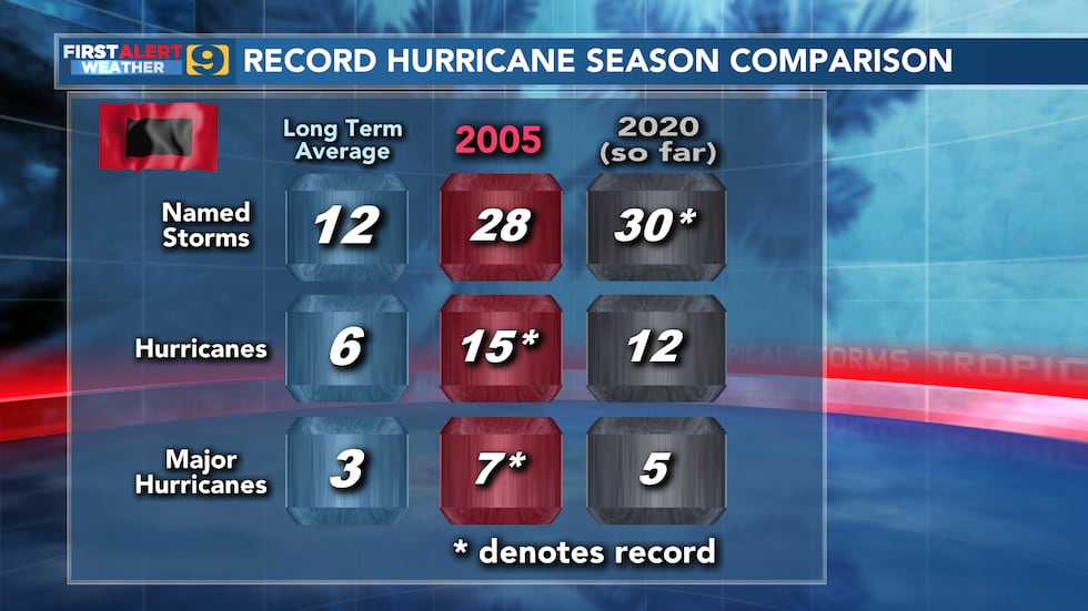
A look at totals comparing 2020 with the record setting 2005 and an average hurricane season shows that 2020 has almost three times the amount of named storms, twice the amount of hurricanes, and almost two times the major hurricanes compared to average. But comparing 2020 to 2005 shows that while 2020 has had the most named storms on record, 2005 still holds the record for hurricanes and major hurricanes.
The season started with two named storms (Arthur & Bertha) before the official start to hurricane season on June 1st. That is not a record as we have seen six consecutive seasons with a named storm forming before the official start date. It certainly began what has become a break-neck pace.
Since the first formation on May 14th, we have averaged 1.2 tropical cyclones per week. Climatologically speaking we are on the downslope of activity with 5% of named storms occurring within the month of November. But 3% of all named storms on record occur outside of June 1 through Nov. 30.
Records:
- tie (w/ 2005) most tropical cyclones (31)
- most named storms (30)
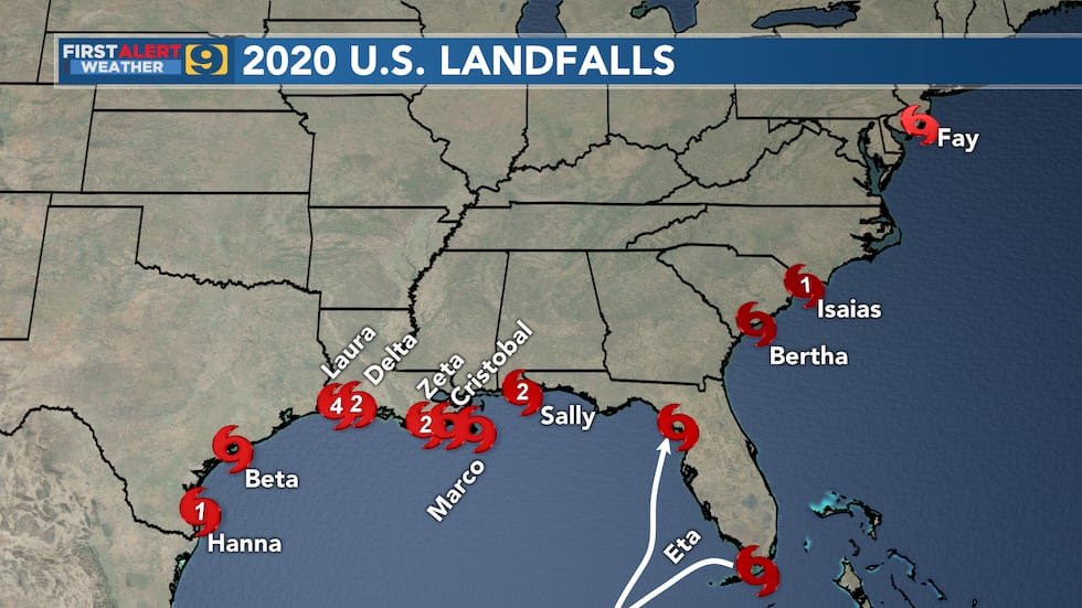
- most U.S. landfalls (12); previous record (9) back in 1916
- most Louisiana landfalls (5)
- tie (w/ 1886 & 1985) most U.S. landfalling hurricanes (6)
- most named storms before Sept. 1 (7)
- September most active month on record (10 named storms)
- Subtropical Storm Alpha 1st named storm to make landfall in Portugal
- Laura tie (1856 Last Island Hurricane) strongest wind speed for Louisiana landfall (150 mph)
Click here to report a typo.
Copyright 2020 WAFB. All rights reserved.